

Emlenton, Pennsylvania
Pennsyltucky describes those parts of Pennsylvania beyond the metropolitan areas of Philadelphia and, sometimes, Pittsburgh. Words like rural, agricultural, deindustrialised, and even Appalachian describe the region briefly. I grew up with the term since I lived in the western suburbs of Philadelphia, and we often used the term pejoratively to describe the western portions of the state. Barack Obama (in)famously described that part of the country in 2008:
It's not surprising then [these small towns in Pennsylvania] get bitter, they cling to guns or religion or antipathy toward people who aren't like them or anti-immigrant sentiment or anti-trade sentiment as a way to explain their frustrations.
Since I moved to Chicago in 2009, I have found few Midwesterners aware of the term. So after publishing two blog posts referencing the term, I was curious if data could provide some explanations or definitions of Pennsyltucky.
During Bob Casey’s campaign for the Pennsylvania governorship in 1986, political strategist James Carville described Pennsylvania as Philadelphia and Pittsburgh with Alabama in the middle.
In a broad sense, urban areas typically vote Democratic and less urban areas vote Republican. So when we look at the history of presidential election results, can we find any patterns about this Pennsyltucky?
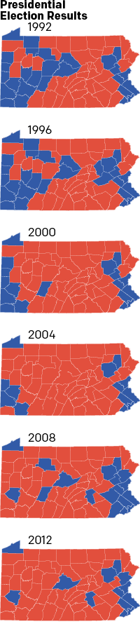
Not surprisingly, most of the Philadelphia metropolitan area of Bucks, Chester, Delaware, and Montgomery counties votes Democratic. Only Chester county represents an outlier as it only voted Democratic in 2008. But, Chester County does not often vote Republican by significant margins. Often the Main Line suburbs are the battleground for Pennsylvania votes.
Just north of Philadelphia we have the Lehigh and Wyoming Valleys. These are home to three of the state’s largest cities: Allentown, Scranton, and Bethlehem. No surprise that the counties where we find these cities have consistently voted Democratic.
We can also explain the northwestern part of the state, that little blue triangle, fairly easily. Erie County is home to the city of Erie, Pennsylvania, the fourth-largest city in the Commonwealth. With a population greater than 100,000 people, Erie represents more than a third of the county’s population.
Further south of Erie we have another non-surprise in one consistently blue county: Allegheny County, home of Pittsburgh, the state’s second largest city. Like Bethlehem, the country’s steel industry once called Pittsburgh home. But now it houses healthcare and technology companies in addition to a reliable bloc of Democratic voters.
So what about this Alabama? Well since 1992 the politics have certainly changed. Solid Democratic votes in the centre of Pennsylvania like Huntingdon, Mifflin, and Juniata counties have turned deep red. The same holds true for the western counties bordering Ohio. In other words, many counties hard hit by deindustrialisation and free-trade policies. But other places like Centre and Dauphin County in the state’s centre now trend Democratic. So Pennsyltucky neither votes consistently red nor consistently blue.
People often describe Pennsyltucky as rural. To an extent, the point is difficult to argue as the Appalachians bisect the state with ridges and folds interrupting the landscape, making transport and settlement difficult. But is the stretch of Pennsylvania between Philadelphia and Pittsburgh entirely rural?
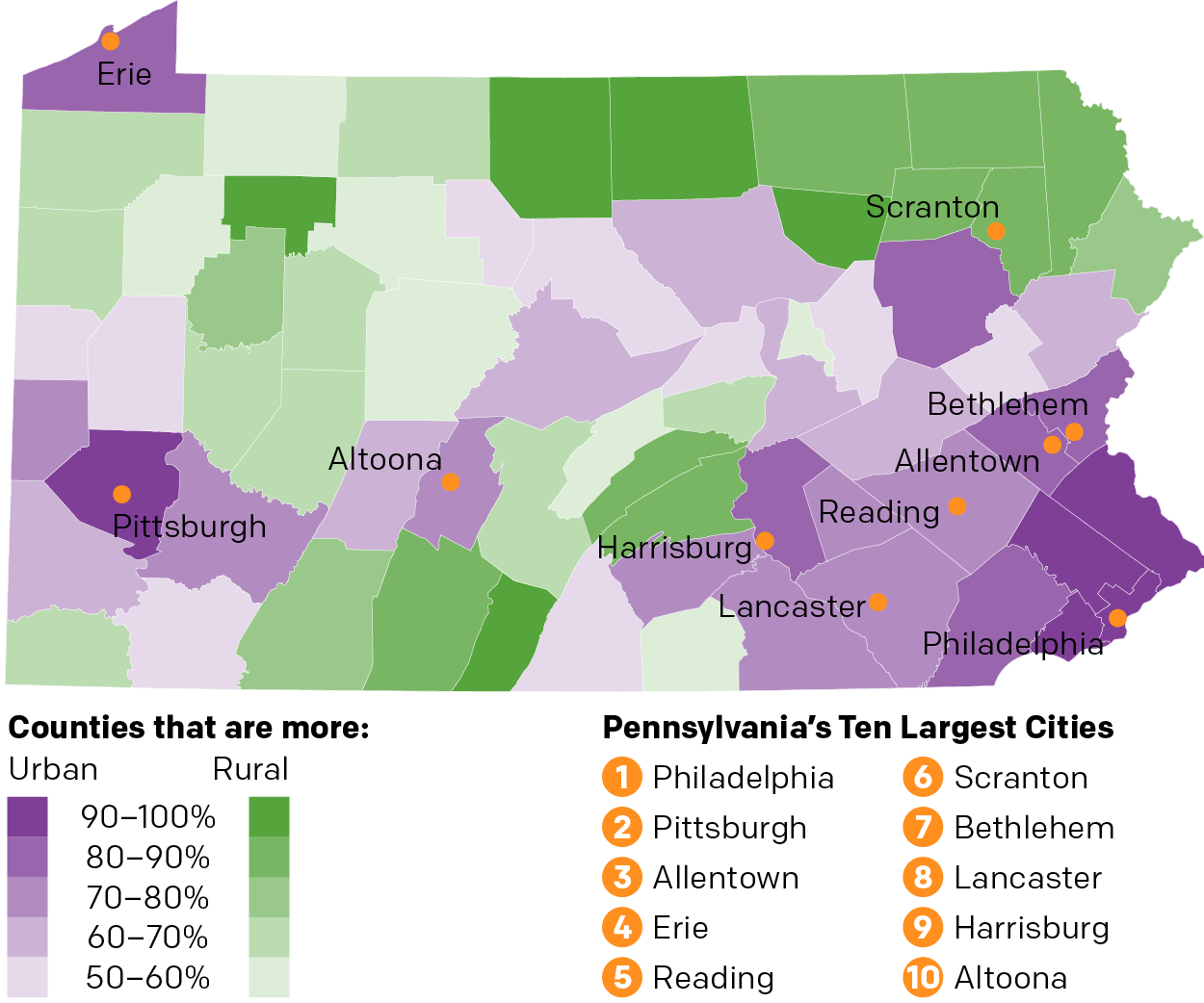
The Philadelphia and Pittsburgh metropolitan areas dominate the southeast and southwest corners of the state. But the map clearly shows that large swaths of central Pennsylvania house urban populations. While Reading can be argued to be part of the Philadelphia metropolitan area, neither Lancaster nor Harrisburg qualify, but they are the eighth and ninth largest cities. And on the opposite side of the Appalachians Altoona clocks in at number ten on the list.
However, the northern third of the state, and the southern, more mountainous ridges of the Appalachians register as more rural than urban. And in places like Bradford, Tioga, Potter, and McKean counties, nearly 100% of the population classifies as rural.
Poverty has long plagued Appalachia, and with Pennsyltucky stretching across Appalachia, perhaps it should come as no real surprise that most of the non-Philadelphia and non-Pittsburgh counties earn less household income than the state median.

Philadelphia’s suburban counties rank extremely high. In fact, as I noted in a blog post from September 2012, Bucks, Chester, and Montgomery County rank among the top-100 highest income counties in the entire United States.
The suburbs of Philadelphia stand in stark contrast to Philadelphia county, coterminous with the city, that ranks second to last, above only tiny Forest County.
Allegheny County, home to Pittsburgh, comes the closest to the state’s median household income. While Fayette and and Armstrong Counties rate lower, the Pittsburgh area still ranks higher than most other counties in Pennsylvania.
The income levels provide the best grouping of what might define Pennsyltucky. While some counties non metropolitan counties appear above the state media, those are places like Northampton, Berks, and Lehigh counties, which are highly urbanised though just outside Philadelphia. Instead, most of the counties in the northern third and centre of Pennsylvania fall below to well below the state median.
When we compare Pennsylvania’s county incomes to those of Alabama’s, we find most of these Pennsyltuckian counties hover near Alabama’s median household income. Outliers still exist, and Alabama has some very poor counties. But it does appear that without Philadelphia’s and Pittsburgh’s counties, the Pennsylvania median household income would fall far closer to that of Alabama’s.
The term Pennsyltucky existed long before I was a kid and it will likely exist long after today. As an undefined region of Pennsylvania, the area of Pennsyltucky will likely grow and contract over time as we have seen it already has in the last 30 years via politics, demographics, and economics.
If we want to define it politically, we would be wise to look at those changing maps. The red spread from the centre as the blue consolidated in urban centres, even in places away from Philadelphia and Pittsburgh like in Harrisburg or Centre County. Nowadays, we could define Pennsyltucky as
Center of the state, right side of the aisle.
But politics is not the only way to define a place. People live there. People work there. Those people tend to be blue collar, living with lower incomes and a more homogenous culture. As jobs vacate the state’s interior, however, I would expect the recent trend of emigration to other states or migration to the bigger cities will continue. And the small towns will get smaller still.
Pennsyltucky is part of the complex socio-economic, geographic, and even political fabric of Pennsylvania. But ultimately for those of from the Philadelphia area, Pennsyltucky will remain a place where
there are some hidden gems, but mostly it’s small town redneck farmsville like.